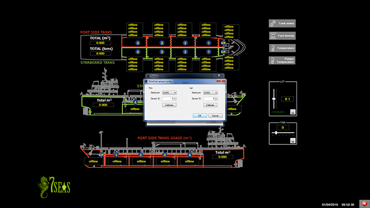
Online tank monitoring system on fuel cargo ships
The system SOTSYS is a tailor-made solution for each vessel that aims at remote monitoring and location of tank levels on fuel cargo ships, static or in motion, as well as temperature reading, geographic location and parameterization of collected data for visualization in an integrated query system.

This system has the integration options of the BMSystem for monitoring the ship's equipment, namely the engines, rotations, temperatures and control of maintenance times, fuel pumps and ballasts in real time and other and equipment capable of sensing.


The implementation of specific equipment to perform the measurements of the ship on an online and local basis, allows the calculation of the volume (m2) and weight (tons) of each tank, the total on port and starboard and in the totality of the cargo, taking into account account for fuel density, temperature and the built-in stability calculation.

The main functionality of this system is the possibility of monitoring, introducing data and corrections from any location with internet access, without the need for any type of human intervention on site.
The collected data are sent to a remote server, where through a portal they can later be consulted in a graphic viewer with the evolution of the cargo levels and the ship's trajectory.
The selection of equipment had as its main requirements, robustness, reliability, compliance with standards and the "maintenance-free" condition, to which the autonomous operation of the system largely contributes, through the selection of energy source, primary or alternatively, with long-lasting batteries that allow constant and uninterrupted operation.
The SS(*) battery charge levels can also be consulted on the web portal page by the system administrator.
The system has autonomy to generate alarms in certain situations.
Ex: Battery levels, abnormal fuel levels and communication failures in the sensors.
Local Server / Pump Control Center / Cargo


Periodically, the SC collects the parameters of the Probe System (SS): level, temperature and voltage of the SS batteries. This process is carried out using radio frequency (RF) and the data is stored in an internal memory together with the sampling date/time and the geographical location of the ship.
Online Server

The SC periodically sends the data via GPRS to a database on the remote server for data processing and storage.
Through an Internet explorer (browser) it is possible to access the database, consult the history of the parameters of the ships.
Each user will have access to the readings of the respective data, as well as access to the drillhole simulator.
In the portal, you can view the geographic location on Google Maps, locating the readings at the date/time they were taken.


